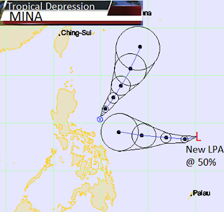
Saturday, December 17, 2011

WEATHER WARNING due to TS Sendong

Effects of Sendong in:
CAPIZ= Flooding
NEGROS PROVINCES=Flooding
ZAMBOANGA DEL NORTE= Flooding
MISAMIS PROVINCES= Flooding
LANAO DEL NORTE= Flooding
LANAO DEL SUR= Flash floods & Landslide
COMPOSTELA VALLEY=Flash floods & Landslide
DAVAO DEL NORTE= Flooding
BUKIDNON= Flooding
===================================================================
SENDONG EFFECTS MAP
COMPOSTELA VALLEY EFFECTS


Thursday, December 15, 2011

Tropical Storm Sendong now aiming for Mindanao

Tropical Storm SENDONG (WASHI)
--------------------------------------------
as of Decmeber 16, 2011 11AM
-------------------------------------------
  • 7.5°N, 127.8°E
  • 180 km East Southeast of Hinatuan, Surigao del Sur 
  • Forecast to move West at 26 kph
  • Heading towards Davao Oriental
  • Maximum winds of 75 kph near the center 
  • Gustiness up to 90 kph
  • 1000hpa Lowest Pressure
Tropical Storm Sendong is now forecast to move westward to the provinces of Davao Oriental. It is already a very long time since last storm hit southern Mindanao. People from Mindanao should take precautionary measures as the storm passing. Please stay indoors or evacuate. 
--------------------------------------------------------------------------------------------------------------------------
TS Sendong Track Map 
Sendong PSWS Map 
JMA Track for Sendong (Washi)

Areas Having Public Storm Warning Signal
PSWS #LuzonVisayasMindanao
Signal No. 2
(60-100 kph winds)
NoneSouthern Leyte
Bohol
Southern Cebu
Southern Negros
Siquijor Island
Surigao Del Norte
Siargao Island
Surigao Del Sur
Dinagat Province
Agusan Provinces
Davao del Norte
Davao Oriental
Samal Island
Lanao Provinces
Misamis Provinces
Zamboanga Provinces
North Cotabato
Compostela Valley
Bukidnon
Camiguin
Maguindanao
Signal No. 1
(45-60 kph winds)
Palawan
Cuyo Island
Eastern Samar
Western Samar
Northern Leyte
Northern Cebu
Northern Negros
Iloilo
Capiz
Antique
Aklan
Guimaras Province
Davao Del Sur
Sultan Kudarat
South Cotabato
Sarangani Province
Basilan Province


Tuesday, October 11, 2011

RAMON threathens Eastern Visayas and Northern Mindanao


Typhoon Ramon (Banyan/23W)
-----------------------------------------------------
As of 5PM October 11,2011
-----------------------------------------------------


  • 8.9°N, 127.9°E
  • 180 ENE of Hinatuan, Surigao Del Sur
  • Forecast to move Northwest at 17 kph 
  • Maximum sustained winds of 65 kph
  • Gustiness of up to 85 kph
  • 1002 hPa Lowest Pressure
===============================================
Ramon Track Map
PSWS MAP of RAMON
JMA Track of BANYAN
IR IMAGE


Areas Having Public Storm Warning Signal
PSWS #LuzonVisayasMindanao
Signal No. 2
(60-100 kph winds)
NoneSouthern Leyte
Eastern Samar
Surigao del Norte
Siargao Island
Surigao del Sur
Dinagat Island
Signal No. 1
(45-60 kph winds)
Masbate
Ticao Island
Romblon
Sorsogon
Northern Leyte
Biliran Island
Bohol
Cebu
Northern Negros
Northern Samar
Western Samar
Panay Island
Guimaras Island
Agusan del Norte
Agusan del Sur
Misamis Oriental
Camiguin Island
TS PROB


Friday, September 30, 2011

QUIEL made Landfall over Isabela


Typhoon PEDRING (NESAT/20W)
-------------------------------------------
as of 5AM October 1, 2011
-------------------------------------------

  • 16.8°N, 123.8°E
  • 160 kms Northeast of Casiguran, Aurora 
  • Forecast to move West Southwest at 26 kph 
  • Heading towards Northern Luzon..
  • Maximum sustained winds of 160 kph near the center
    Gustiness of up to 195 kph
  • minimum sea level pressure: 935hPa
======================================================================
JAPAN TRACK OF QUIEL
Public Storm Warning Signal as of 5 AM
Satellite Animation of Quiel
====================================================================
Areas Having Public Storm Warning Signal
PSWS #LuzonVisayasMindanao
Signal No.3
(100-185 kph winds)
Isabela
Northern Aurora
Mt. Province
Ifugao
Nueva Vizcaya
Quirino
Benguet
Ilocos Sur
La Union
Pangasinan
NoneNone
Signal No. 2
(60-100 kph winds)
Cagayan
Apayao
Ilocos Norte
Abra
Kalinga
Rest of Aurora
Nueva Ecija
Tarlac
Pampanga
Zambales
Bulacan
Northern Quezon
Polillo Island
NoneNone
Signal No. 1
(45-60 kph winds)
Rest of Quezon
Camarines Norte
Rizal
Bataan
Cavite
Laguna
Batangas
Lubang Island
Babuyan Is.
Calayan Group of Is.
Metro Manila
NoneNone
SMALL EYE - over water (North Philippine Sea)...expected to landfall off the shores of Isabela between 8-10 AM today. Possible calm and lull conditions (with <20 kph winds) will be expected inside the eye
 EYEWALL - affecting and moving into the shores of Northern Aurora-Isabela this morningTyphoon Conditions with Typhoon Force Winds (>118 kph) will be expected within this wall
 INNER RAINBANDS - affecting and spreading across Northern Aurora & IsabelaTropical Storm Conditions w/ Tropical Storm Force Winds (62-117 kph) will be expected along these bands.
 OUTER RAINBANDS - affecting & spreading across Northern & Central Luzon incl. Metro Manila, Southern Luzon, & Camarines Norte. Tropical Depression Conditions w/ moderate to strong winds (25-61 kph) will be expected along these bands
 24HR TOTAL RAINFALL ACCUMULATION - from 5 up to 100 mm (low to high rainfall) can be expected along areas affected by the outer & inner rainbands (see above)...with isolated amounts of 101 to 210 mm (high) along areas near the center of NALGAE (QUIEL).
 COASTAL STORM SURGE FLOODING - possible 13-18 ft [4-5.5 m] above normal tide levels...accompanied by large and dangerous battering waves can be expected along the coastal and beach front areas of Eastern Luzon particularly Isabela & Aurora today. Extreme damage is likely on this type of storm surge. Danger from Rip Currents or Rip Tides can be expected along the beach-front areas of Luzon.


Monday, September 26, 2011

Pedring Slightly Instefies; continues to endanger Luzon Isle


Typhoon PEDRING (NESAT/20W)
-------------------------------------------
as of 1 P.M PST 05/23/2011
-------------------------------------------

  • 15.6°N, 124.8°E
  • 260 km East Southeast of Casiguran, Aurora
  • Forecast to move West Northwest at 19 kph 
  • Heading towards Luzon
  • Maximum sustained winds of 130 kph near the center
    Gustiness of up to 160 kph
  • minimum sea level pressure: 965hPa


Areas Having Public Storm Warning Signal
PSWS #LuzonVisayasMindanao
Signal No.3
(100-185 kph winds)
Catanduanes
Camarines Sur
Camarines Norte
Northern Quezon
Polillo Island
Aurora
Quirino
Isabela
NoneNone
Signal No. 2
(60-100 kph winds)
Albay
Burias Island
Sorsogon
Rest of Quezon
Rizal
Bulacan
Nueva Ecija
Nueva Vizcaya
Ifugao
Benguet
Mt. Province
Kalinga
Cagayan
Metro Manila
NoneNone
Signal No. 1
(45-60 kph winds)
Ticao Island
Masbate
Marinduque
Batangas
Cavite
Bataan
Laguna
Pampanga
Zambales
Tarlac
Pangasinan
La Union
Ilocos Sur
Ilocos Norte
Abra
Apayao
Calayan
Babuyan Group of Islands
Northern SamarNone

Tyhpoon Pedring endagers Luzon Isle


Typhoon PEDRING (Nesat/20W)
--------------------------------------------
as of 11AM September 26, 2011
-------------------------------------------
  • 15.5°N, 125.6°E
  • 350 km East Southeast of Casiguran, Aurora
  • WNW @ 17kph
  • Heading towards Quirino - Aurora
  • 120 kph Sustained Winds
  • 150 gustiness winds near center
  • minimum sea level pressure: 965 hPa
========================================================================
Typhoon Track with Wind Radius
Signal Distribution Map
Typhoon Pedring Satellite Animation (Wunderground Tropical)

Tropical Storm Wind Probability
Areas Having Public Storm Warning Signal
PSWS #LuzonVisayasMindanao
Signal No. 2
(60-100 kph winds)
Catanduanes
Sorsogon
Albay
Burias Island
Camarines Sur
Camarines Norte
Quezon
Polillo Island
Aurora
Quirino
Nueva Vizcaya
Isabela
Ifugao
Cagayan
NoneNone
Signal No. 1
(45-60 kph winds)
Metro Manila
Masbate
Ticao Island
Marinduque
Batangas
Laguna
Rizal
Cavite
Bulacan
Pampanga
Nueva Ecija
Tarlac
Bataan
Zambales
Pangasinan
La Union
Benguet
Mt. Province
Ilocos Sur
Ilocos Norte
Abra
Kalinga
Apayao
Calayan
Babuyan Group of Islands
Northern SamarNone


Saturday, August 27, 2011

Typhoon Mina weakens; Continues to batter Northern Luzon

Typhoon Mina (Nanmadol/ 14W)
---------------------------------------------
As of 5PM August 27, 2011
-------------------------------------

  • 18.7°N, 121.9°E
  • 50 km Northeast of Aparri, Cagayan
  • Maximum sustained winds of 165 kph
  • Gustiness of up to 200 kph
  • Northwest at 7 kph 
----------------------------------------------------------------------
Typhoon Mina Track Map
------------------------------------------------------------------------
Storm Signals Map
=======================================================
Areas Having Public Storm Warning Signal
PSWS #LuzonVisayasMindanao
Signal No.3
(100-185 kph winds)
Cagayan
Babuyan Group of Island
Calayan Group of Island
Apayao
Batanes
NoneNone
Signal No. 2
(60-100 kph winds)
Ilocos Norte
Ilocos Sur
Abra
Kalinga
Mt. Province
Ifugao
Isabela
NoneNone
Signal No. 1
(45-60 kph winds)
La Union
Benguet
Pangasinan
Nueva Ecija
Nueva Vizcaya
Quirino
Aurora
NoneNone


Friday, August 26, 2011

Super Typhoon Mina made Landfall; Strong winds will still blow trough Metro Manila


Typhoon Mina (NANMADOL/14W)
-----------------------------------------------------
As of 11AM August 27,2011
-----------------------------------------------------

  • 18.2°N, 122.3°E
  • 90 km Northeast of Tuguegarao City 
  • Forecast to move Northwest at 7 kph 
  • Maximum sustained winds of 195 kph 
  • Gustiness of up to 230 kph
  • 930 hPa Lowest Pressure
===============================================
===========================================
Areas Having Public Storm Warning Signal
PSWS #LuzonVisayasMindanao
Signal No. 4
( >185 kph winds)
Northern Cagayan
Calayan
Babuyan Group of Islands
NoneNone
Signal No.3
(100-185 kph winds)
Isabela
Apayao
Rest of Cagayan
Batanes Group of Islands
NoneNone
Signal No. 2
(60-100 kph winds)
Northern Aurora
Quirino Ifugao
Mt. Province
Kalinga
Ilocos Norte
Iocos Sur
Abra
Benguet
La Union 
NoneNone
Signal No. 1
(45-60 kph winds)
Rest of Aurora
Nueva Vizcaya
Nueva Ecija
Pangasinan
Tarlac
Zambales
NoneNone
=======================================================
Gale Warning and Strong Warning Maps
==========================================================
Weather Warning Maps

=======================================================
TYPHOON MINA is far from Metro Manila but it will continue to enhance the SW Monsoon and the SW Windflow. We will continue to experience Winds and Rains for the next hours..

Super Typhoon Mina undergone to a Eyewall Replacement Cycle making it category 5 storm


Super Typhoon Mina (Nanmadol/14W)
-----------------------------------------------------------------
As of 9PM August 26,2011
-----------------------------------------------------------------

  • 17.5 N 123.3E
  • Moving NW @ 13kph
  • heading towards the Northern Luzon
  • 250 kph Sustained Winds
  • 260 kph Gustiness Winds
  • minimum sea level pressure: 920 hPa
-------------------------------------------------------------------------------------------------------------------
Super Typhoon Mina Track
-------------------------------------------------------------------------
JMA Track of Mina
--------------------------------------------------------------------
Typhoon Mina Baler Radar Capture
-----------------------------------------------------------------------------------
SIGNAL BULLETIN
SIGNAL NO.4Northern Cagayan
SIGNAL NO.3Isabela
Rest of Cagayan
Calayan
Babuyan Group of Island
Batanes Group of Island

SIGNAL NO.2
Northern Aurora
Quirino
Ifugao
Mt. Province
Kalinga
Apayao

SIGNAL NO.1
Rest of Aurora
Nueva Vizcaya
Benguet
Ilocos Sur
Ilocos Norte
Abra
------------------------------------------------------------------------------------------------------------------------------------
SUPER TYPHOON MINA WARNING FOR MANILA ::::
         Even STY Mina (Nanmadol) is far from Metro Manila, it will still continue to bring STRONG RAINS AND WINDS  (winds reaching 55 kph) and rains ranging ftom moderate to heavy...........
The said storm is a STY, so Metor Manila, Southern Luzon, Bicol Region, Central Luzon must watch for Winds Reaching 55kph and above even not though the province is not under any Public Storm Signal...

Thursday, August 25, 2011

Typhoon Mina moving West instead of NNE; Northern Luzon Endangered


Typhoon Mina (Nanmadol/11W)
-----------------------------------------------------------------
As of 6PM August 25,2011
-----------------------------------------------------------------

  • 16.5N 127.4E
  • 260 km East of Casiguran, Aurora 
  • Moving WNW @ 13kph
  • heading towards the Northern Luzon
  • 150 kph Sustained Winds
  • minimum sea level pressure: 965 hPa
-------------------------------------------------------------------------------------------------

Typhoon Mina Track
JMA Nanmadol Track
------------------------------------------------------------------------------
Signal No. 2 = 
Northern Aurora
IsabelaCagayan


Signal No. 1 =
Rest of Aurora
Nueva Ecija
Nueva Viscaya
Quirino
Ifugao
Mt. Province
Kalinga
Apayao
Calayan
Babuyan
Batanes Group of Islands

Friday, July 29, 2011

As JUANING moves out of PAR; KABAYAN enters PAR

SWMS is Moderate for Central Luzon, Southern Luzon, Bicol Region, Northern Eastern Visayas.
Weather Map for Philippines, (CLICK for Larger Version)

Tuesday, July 26, 2011

Typhoon JUANING made landfall over Auroa

Typhoon JUANING (Nock-Ten/10W)
--------------------------------------------
as of 11PM PST July 27,2011
-------------------------------------------


  • 16.0N 122.0E
  • 40km SE of Casiguran, Aurora
  • 205km NNE of Manila City
  • NW@15kph
  • heading towards Quirino-Nuva Vizcaya
  • 120kph sustained winds
  • 150kph Gustiness winds
  • minimum sea level pressure: 985hPa
  • Size: 590km in diameter
=============================================================================
Tyhpnoo JUANING Track Map and PSWS Map
Tyhpoon JUANING Satellite Animation (Wunderground Tropical)
===================================================================
Signal No.2 
Aurora
Quirino
Nueva Vizcaya
Abra
Kalinga
Ilocos Sur
Mt Province
Isabela
La Union
Benguet
Ifugao
Pangasinan
Zambales
Tarlac
Nueva Ecija
Pampanga
Bataan
Bulacan
Rizal
Quezon
Polillo Island
Metro Manila
Signal No.1
Ilocos Norte
Apayao
Cagayan
Cavite
Batangas
Laguna
Mindoro Provinces
Lubang Island
Marinduque
Camarines Norte
Camarines Sur
Albay
Burias Island
===============================================================================
Tropical Storm Strength Probability for
=================================================================================
RAINFALL FOR THE PAST 24HRS.